Click for Penny/Bill website contents
Click for home/contacts page of www.summitco.us
THE MYSTERY OF SKULL
ROCK—an association with the great Lake Bonneville Flood? Or? Draft 09/11/2016
by William R Jones. The wise man once
said, "Give me one fact and I can write volumes. Give me two facts and I am
confused." What started with one fact--seeing an unknown rock that seemed in a
strange place, became many facts.
I mentioned Skull Rock in a recent email. It’s in western Utah, a half-mile or so east of where US
Highway 6/50 passes through Skull Rock Pass, and is a half-mile or so south of
the highway, on a slope above usually dry Sevier Lake, which is east of Skull
Rock. Penny and I recently traveled on the highway past the rock and I saw it
once again, having passed and noticed it many times before although not knowing
its name or thinking about it too hard. I found a picture of the rock on the
internet, copied below, and you can see how out of place the rock seems. I don’t
know the composition of Skull Rock, but it is light-colored; it sits on an
alluvial fan that appears to have been deposited on what appears to be
brownish-gray shale. Knowing more about the rock types of Skull Rock and that of
the nearby bedrock could be useful but I have never walked to Skull Rock or the
bedrock, always being on a trip with other agendas. (New info from
master’s thesis “The Geology of Southern House Range, Millard County, Utah “ by
D. Keith Powell, 1958. Powell and others mapped limestones in the region but
others appear to have classified these as shale as they appear to be a mix of
shale and limestone.) There are a few other rocks nearby that in appearance are
similar to Skull Rock and there may be another smaller rock behind it and out of
sight in the picture. Skull Rock is so prominent that it is named on topo maps
and gives its name to adjacent Skull Rock Pass on the highway.
I first noticed this
rock decades ago and have since then been puzzled by how the rock got where it
is. I only learned its name and that of the nearby pass after my last trip past
them with Penny once I began to look at topo maps to try to understand Skull
Rock better. On this trip and afterward I began coming up with hypotheses of
possible explanations of how Skull Rock got to where it is. Skull Rock looks
like a glacial erratic, but there are no moraines or other glacial evidence
around Skull rock or upslope from it. There are no nearby cliffs down from which
it could have rolled. It is too big to have been blown there by the wind-unless
it slid on slick mud or ice. It does not appear to be of volcanic
origin--although an up-close look might show otherwise. If it is of volcanic
pumice or welded tuff (solidified ash) it could be lighter than water and if so
would float! (In the region of Skill Rock there are recorded deposits from the
Bishop tuff, which erupted in the Long Valley area of eastern California
1.9-0.6 million years ago that are up to almost 10 feet thick). Could it be a
concretion or other inclusion or intrusion that weathered from the shale? Could
it have floated to its spot in an iceberg calved from a valley glacier feeding
into a great lake or on an ice floe or a raft of logs back when Sevier Lake was
full and perhaps its surface frozen at times? Skull Rock Pass goes through a
road-cut that is riddled with faults but they do not seem to be related to Skull
Rock and are a distance away from it. To the west, however, a fault scarp with
10,000 feet of vertical displacement occurs and there are thrust faults mapped
in the area. With the information available there are too many potential
explanations and yet there still may be more than the ones mentioned. How could
I narrow the choices?
It probably does not
matter from an economic standpoint much where Skull Rock came from or what it is
(unless it contains gold—gold has been found upslope in the House Range, is
radioactive, or?). Still, its unusual character was and is intriguing to me. Who
knows? Understanding the mystery of Skull Rock might help understand something
greater?
A line of inquiry
that seemed worth considering was that the rock is somehow associated with one
of the expansive lakes that were present during the main recent glaciation of
the Great Basin. I remember a lecture on these years ago at the Sacramento
Geological Society by an enthusiast who had made maps of these lakes based on
remnant shorelines on desert cliffs. In Nevada, archaeological sites have been
found alongside these ancient shorelines, too, where natives likely found brush
for shelters, water, and food in the land animals that came to drink; waterfowl
who nested, reared, and migrated to and from the lakes; brush for their houses;
and maybe even fish to eat as we know at least some were present as in the tiny
pupfish now found in desert streams and potholes that presumably are remnant
populations of their ancestors once present in the large lakes.
So I dug out a report—mainly a map with references to sources used in making it-- I’ve had
sitting in my basement for years, Pleistocene
Lakes in the Great Basin, published by the U.S. Geological Survey in
1964. The map includes eastern California (east of the Sierra Nevada), most of
Nevada, western Utah, southwestern Idaho, and southeastern Oregon—all desert
areas today where the present streams drain into basins only to flood them
during wet periods and/or dry up in them. Eyeballing this map, I guessed that
about ¼ of its area is colored blue, reflecting the amount of water present then
in what is a mainly dry region today. A similar map is copied below:
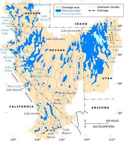 I found on the map
that the ancient lake once near Skull Rock--Sevier Lake--was much larger in the
Pleistocene period than it is now, so large that it connected with other lakes
including the predecessor of Great Salt Lake. This whole ancient complex of
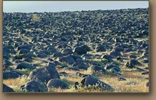
former lakes is called Lake Bonneville. And here is something I only learned
about a few weeks ago on a visit to Shoshone Falls near Twin Falls, Idaho, where
the Snake River drops over 200 feet into a canyon carved into a wide flat valley
littered with polished boulders called “petrified watermelons” mainly of basalt
rock, shown below:
I found on the map
that the ancient lake once near Skull Rock--Sevier Lake--was much larger in the
Pleistocene period than it is now, so large that it connected with other lakes
including the predecessor of Great Salt Lake. This whole ancient complex of
former lakes is called Lake Bonneville. And here is something I only learned
about a few weeks ago on a visit to Shoshone Falls near Twin Falls, Idaho, where
the Snake River drops over 200 feet into a canyon carved into a wide flat valley
littered with polished boulders called “petrified watermelons” mainly of basalt
rock, shown below:
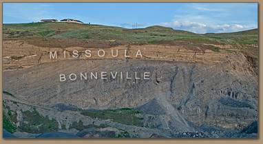
About 14,500 years
ago Lake Bonneville, after having filled to a high stand, partially emptied to
the north through Red Rock Pass in a catastrophic flood—the Bonneville
Flood—down to the Snake River in Idaho, the lake's level dropping rapidly. (This
was one of the few times if not the only time when at least some waters of this
region did not just evaporate but instead reached an ocean; this flood preceded
by a few thousand years the Missoula Flood and is not related to it except they
both eventually flowed down the Columbia River and so there are Bonneville
Flood deposits underlying Missoula Flood deposits downstream of where the two
floods at different times crossed paths.
The high stand of Lake Bonneville (before it began draining into the Snake River)
is shown by shorelines above
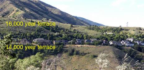 Salt Lake City and
 elsewhere at 5170 feet, higher than the current level (4790 feet) of Red Rock Pass in
Idaho, through which Lake Bonneville drained when alluvial deposits from
hillsides adjacent to the pass were breached and removed by the cascading water.
elsewhere at 5170 feet, higher than the current level (4790 feet) of Red Rock Pass in
Idaho, through which Lake Bonneville drained when alluvial deposits from
hillsides adjacent to the pass were breached and removed by the cascading water.
Thus about 380 vertical feet of water drained out, it is said in a wall of water 300 feet
high that took 8 weeks to exit. As the material at Red Rock Pass eroded , there
may have been more resistant layers that could not at first be removed as
rapidly, and—just as with modern reservoirs when they are full—wind-driven waves
could at such times have created descending shorelines. Lake Bonneville’s Sevier
Lake arm would also have dropped its level rapidly and in corresponding
pulsations, at least until the Sevier Lake arm became isolated by ridgetop
saddles from what became the Great Salt Lake. But where does Skull Rock sit in
relation to these ancient lake shorelines? The map of Pleistocene lakes shows
the shoreline of ancient Sevier Lake as being near Skull Rock but the map’s
scale is such that one cannot tell how near the shoreline is or whether upslope
from the rock or downslope.
What does the internet have to tell about Skull Rock? On the internet I found the picture
below of Skull Rock. At first I did not notice the horizontal lines in the lower
half of the view. And when driving past the rock these many times over the years
I did not notice these lines on the real landscape, either. Could they be lake
shorelines? If so, Skull Rock was in or on a lake. What lake? Skull Rock sits at
an altitude of 5170 feet, according to the USGS topo map. Thus the altitude of
Skull Rock is the same, give or take a few feet, as that of the high stand of
Lake Bonneville. This correlation of the altitude of Skull Rock with the highest
level of Lake Bonneville confirms that Skull Rock was in the lake near the shore
before the big draining and supports the notion that Skull Rock’s arrival at its
present site may somehow be related to Lake Bonneville. But still—what process
was involved?
Assuming Skull Rock is not in situ—that is eroded from what underlies it—
Did Skull Rock get to its location before the lake covered it?
When the rock was covered by the lake?
Or after the lake
level fell below it? Answering these
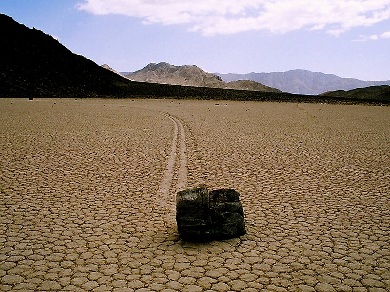
questions brings to mind the sliding rocks of the Racetrack Playa in Death
Valley, where rocks have slid across mudflats long distances, blown by wind over
slick mud. Those rocks, however, are not as large as is Skull Rock and they are
at the bottom of what is now a dried-up lake instead of near the top of an
existing one as would have been Skull Rock. But as Lake Bonneville drained,
Skull Rock may have been on a mudflat, too, and perhaps did some similar moves
when the mud was slick and the wind blew against its face. Or there was ice.
(Movement of rocks across flat surfaces is well documented at Devils Racetrack in Death Valley, California.)There are also left the possibilities of rafting by ice or logs or floating if
the rock is of tuff, and ? Too bad we weren’t there to see what happened, but
perhaps some humans were, depending on how dating of their first presence is
interpreted and when the rock moved.
So I still do not have a definitive origin for Skull Rock. Next steps: determine the rock types of
Skull Rock and the nearby bedrock and see how those fit into the regional
geology to determine where Skull Rock originated and what its porosity and
density are in relation to water. And look at other nearby loose rocks to see
what they are and if similar to Skull Rock. See what new ideas might come up.
Some of these are outlined below the pictures.
If only the rocks
could talk, what stories they could tell! I have had discussions about the method of working multiple hypotheses. This interim report
on Skull Rock is an example of how that works. Unfortunately the method has not
yet revealed the answer sought though it may be getting closer. This tedious
process, however, could bore some and inspire them to use other methods of
reasoning to find how Skull Rock got to where it is.
Bill Jones
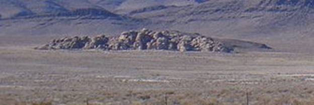
Skull Rock--are horizontal lines lake shorelines?
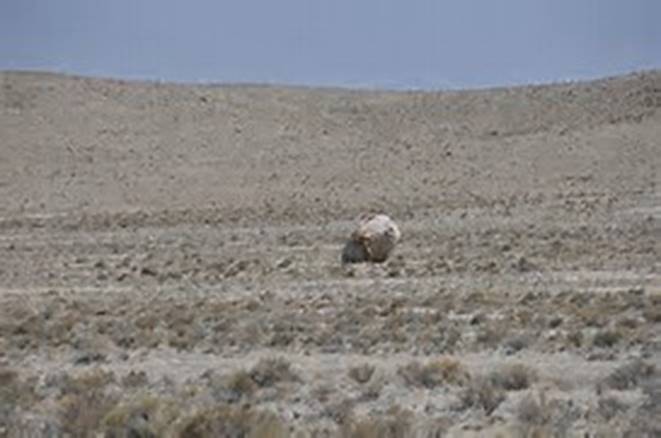
Below is an aerial photo of Skull Rock (faint parallel wheel tracks on the left give scale):
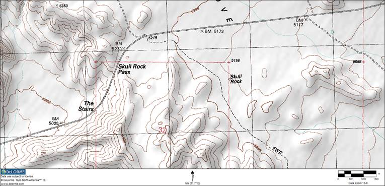
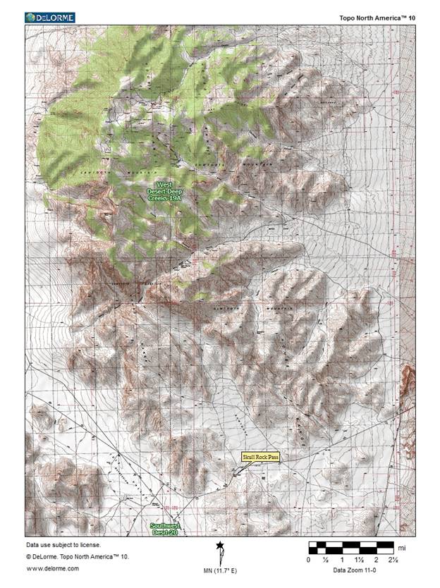
Topo map of Skull Rock location, south of US Hwy 6/50 (shown), east of Skull Rock Pass, western
Utah. Printed names are on original map:
Disclaimer: Much of what is presented here comes from secondary or tertiary sources, much from the
internet. USGS Board on Geographic Names: In 1961 Skull Rock Pass name recorded, named for nearby Skull
Rock, latter name in local usage.
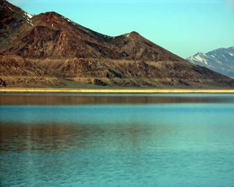
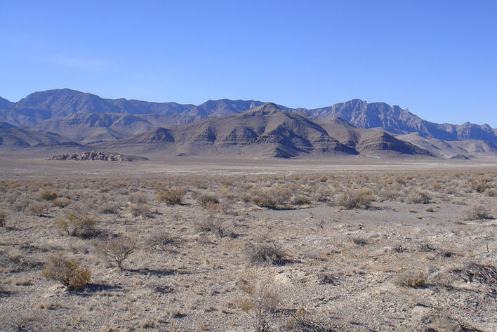
Below is a photo of the Confusion Range (looking north from Skull Rock Pass, as identified on
Wikipedia when search is on "Confusion Range"). The horizontal lines in the
upper slopes may be flat-flying shale or limestone beds. The horizontal
lines in the alluvial fan deposits in the lower part of the photo may be ancient
shorelines, which would put the lake level a bit higher (say 20-40 feet) than
where Skull Rock sits at circa 5160. But one wonders what the lighter-colored
blocky material in the left middle of the alluvial fan is, and whether this is
where Skull Rock came from. That same material may crop out at the base of the
slopes on the right. So Skull Rock could be just an erosional remnant of that
different formation. A good geological map or a site visit would shed more light
on this. Note the fineness of the material in the foreground; could it be tuff?

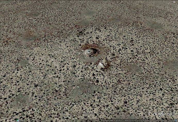
Below is an enlargement of that outcrop at left center of the above photo. What is the
material? Could it be tuff? Or tufa (hot water spring deposit)? Or blocky
limestone? Or? Perhaps granitic?
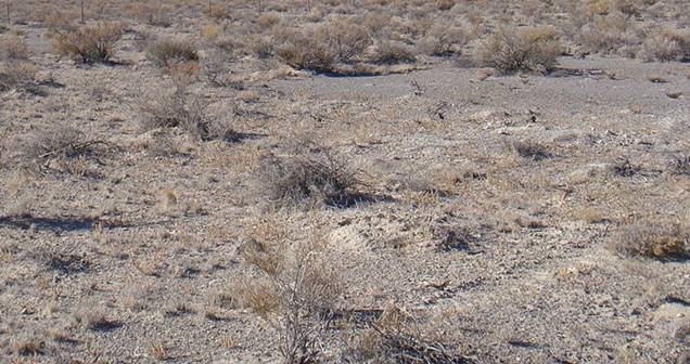
Below is an enlargement of the soil in the alluvial fan in the foreground of the above
picture of the Confusion Range from Skull Rock Pass. Could this be tuff or tufa
fragments? Or fines from a lake bed? Or? (For fun, note, too, the spacing of
the plants. “A desert is where there are spaces between the plants”. This could
be from sparse water available to the plants or to chemicals that some plants,
such as creosote bush, produce to inhibit growth near them)?
Below is a topo map of the region of Skull Rock Pass. Note the linearity of the canyons and some
minor gullies trending northwest-southeast, although a bit suggestive, that is
probably parallel to the faults in Skull Rock Pass (depending on another look at
those faults). Perhaps the lighter-colored outcrop in the alluvial fan (which
outcrop is in the middle of the flattish area north of Skull Rock Pass) is a
sliver that was dragged into place along a fault from below or somewhere else
and Skull Rock is just a chunk of that. But still, if the outcrop was so dragged
by faulting to its present location, how did Skull Rock itself get downslope
from there? Or is it all that is left of another fault sliver some of which may
still be buried under Skull Rock or otherwise completely eroded away? (Now we
need to drill into the alluvial fan to find out.) Could it have rolled or slid
down such a gentle slope as that of the alluvial fan--on ice or mud or? Or did
it detach from the visible outcrop, fall into or near the lake, and slide on
mud, float, be rafted on ice, or whatever to its present location? (See the photo of Devils Racetrack, or Racetrack Playa, from Death Valley, California):
Click for Penny/Bill website contents
Click for home/contacts page of www.summitco.us
This page is htttps;//www/summitco.us\pages\sumskullrock.html. It was last modified
January 4, 2024
Copyright © 2016 Elizabeth A. Kerr & William R Jones.